
DataBASE DEVELOPMENT & MANAGEMENT
Advantages of Database Management:
- Centralized control of information
- Redundancy control
- Improved data integrity and security
- Flexible conceptual design
- Quick access to customized reports
- Data verification, validation, and qualification
- Link to programs (ArcView GIS) for customized maps
- Secure remote access through VPN or FTP connections
- Integration of multiple data sets to provide a more complete project picture
- No expensive, special software investments required
Western Water & Land, Inc. offers a full range of data management services designed to ensure and protect data integrity. Our data management professionals have developed databases for a broad range of industries, including domestic water providers, irrigation companies, energy companies, municipalities, U.S. Forest Service, and U.S. Bureau of Land Management. Our experience includes management of operational data; process data; analytical results and quality assurance reports for surface water, groundwater, soil, sediment, and vegetation samples; surface water flow rates; and groundwater level information.
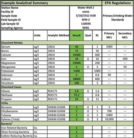
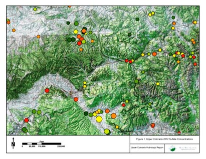
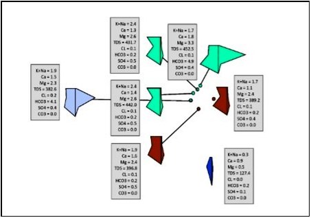
Using our expertise in managing environmental data, we have developed project-specific databases using common office software (MS Access and Excel) that not only store project data, but also perform data QA/QC, statistical analyses, run pre-programmed queries, compare results against regulatory standards, and provide custom reports that retrieve desired data in a matter of minutes. The database can be designed and customized to manage any type of information associated with the project, including geographical coordinates, maps, lithology, laboratory analytical data, continuous monitoring equipment data, permitting documents, etc. Data can be exported to programs such as ArcGIS™ to plot sampling locations and view water chemistry from a spatial perspective, or to programs like MODFLOW/M3TD™ for hydrologic modeling and analysis.
Using our expertise in managing environmental data, we have developed project-specific databases using common office software (MS Access and Excel) that not only store project data, but also perform data QA/QC, statistical analyses, run pre-programmed queries, compare results against regulatory standards, and provide custom reports that retrieve desired data in a matter of minutes. The database can be designed and customized to manage any type of information associated with the project, including geographical coordinates, maps, lithology, laboratory analytical data, continuous monitoring equipment data, permitting documents, etc. Data can be exported to programs such as ArcGIS™ to plot sampling locations and view water chemistry from a spatial perspective, or to programs like MODFLOW/M3TD™ for hydrologic modeling and analysis.
|
|