
Land Health Assessment Projects
|
Water Rights Due Diligence & Demand Evaluation
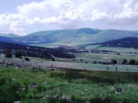
Parker Basin Ranch, Mesa County, Colorado Western Water & Land was retained to provide water rights due diligence support for acquisition of a 3,000-acre ranch in Mesa County, Colorado. Water rights associated with the property were evaluated to ensure the legal and physical availability of the water was sufficient to meet the irrigation demands at the ranch. Read more... |
|
Water Rights & Water Availability Assessment
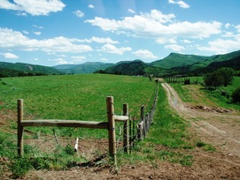
Sunrise Canyon Ranch, Delta County, Colorado Western Water & Land completed an evaluation of the water rights and water availability and permitted wells associated with the potential sale of land comprising the Sunrise Canyon Ranch. The evaluation was performed to help verify how well the water rights and supply available have historically met the needs of the land. Read more... |
|
Water Rights & Water Availability Assessment
US National Bank Association, Delta County, Colorado Western Water & Land was retained to assess legal and physical availability of the water rights and the usefulness of the water rights for the water needs of the property. US National Bank had retained a property from foreclosure and was being offered water rights from Gove Ditch which is ultimately tributary to Smith Fork for use on the property. Read more... |
|
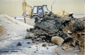
Mill Tailings Impact Assessment
Telluride, Colorado Fluvial transport of mill tailings from former milling operation upstream of the Town of Telluride has resulted in tailings deposits along the San Miguel River on U.S. Forest Service land comprising a portion of the Telluride Valley Floor. The deposits occur in areas heavily used by hikers, bikers, and anglers. Read more... |
|
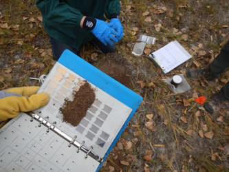
Soil Investigation/Remediation
Grand Junction, Colorado A Phase 2 subsurface investigation was conducted at a former bulk oil distribution facility in Grand Junction, Colorado. Surface stains on soil underlying surface gravel indicated potential oil contamination within a former product storage area. Up to 5 above-ground storage tanks had been previously stored at the site. Read more... |
|
Firing Range Remediation
Grand Canyon National Park, Arizona Western Water & Land conducted a complete characterization and remediation of two small-arms firing ranges the National Park Service (NPS) at Grand Canyon National Park. The first phase of the project involved soil contaminant characterization of surface and subsurface soils. Read more... |
|
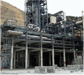
RCRA Facility Investigation
Parachute, Colorado A Resource Conservation and Recovery Act (RCRA) Facility Investigation was conducted at the former Parachute Creek Shale Oil Facility. The investigation was conducted pursuant to an Order on Consent between the facility and the Colorado Department of Public Health and Environment (CDPHE). Read more... |
|
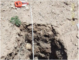
Radiological Characterization
Moab, Utah A subsurface soil investigation was conducted in support of the baseline radiological soil characterization at the Moab Mill Site located near Moab, Utah. The purpose of the characterization was to provide the data needed to assess radiological levels as well as the lateral and vertical extent of contaminated soil in areas where subsurface contamination was expected on the basis of site history and operational practices. Read more... |
|
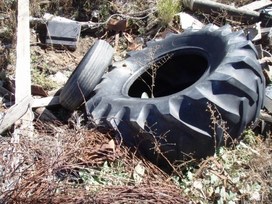
Site Investigation and Cleanup
Private Ranch Lands, Steamboat, Colorado Western Water & Land was retained to investigate an unapproved trash dump and identify potential soil contamination on private ranch land prior to the sale of the property. The preliminary investigation included characterization of the visible waste present at the dump as hazardous or non-hazardous; the development of a waste removal strategy; and soil sampling and analysis to compare presence of heavy metals to EPA Regional Screening Levels and BLM Risk Management Criteria. Read more... |
|
Brewery Waste Characterization and Soil Assessment
Town of Palisade, Palisade, Colorado In response to a compliance advisory issued by the Colorado Department of Public Health and Environment, Western Water & Land was retained to investigate potential soil contamination caused by the improper land application of brewery and distillery wastewater and develop a soil cleanup strategy based on EPA Regional Screening Level (RSL) criteria. Read more... |
|
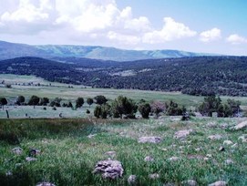
Irrigation Water Requirements to Support Winter Wildlife Habitat: Mesa Land Trust
Collbran, Colorado Western Water & Land was retained by a regional land trust organization to provide litigation support for a dispute between the land trust and the former owner of a ranch at which a conservation easement had been created several years prior. The conservation easement was established to ensure winter habitat and forage for wildlife in the area. Read more... |

|
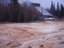
Uranium Mine Land Assessment: La Sal Creek Watershed Project
San Juan County, Utah & Montrose County, Colorado Western Water & Land technically directed, and implemented the La Sal Creek Watershed project which was conducted on behalf of the U.S. Bureau of Land Management (BLM) to address human health and ecological risks associated with former operations at five abandoned uranium mine sites in eastern Utah and western Colorado. Read more... |
|
Mine Land Screening Assessment Workshop: U.S. Forest Service
Grand Mesa, Uncompahgre, & Gunnison National Forests Western Water & Land conducted a one-day workshop for U.S. Forest Service personnel responsible for acquisition, management, and maintenance activities on Forest Service Lands impacted by former mining and milling operations. The workshop was requested by the Forest Service in response to its ongoing acquisition of numerous patented mining claims throughout the GMUG National Forests. Read more... |
|
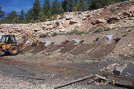
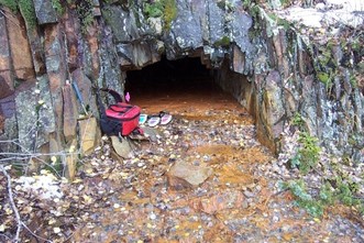
Mine Land Assessments: Abandoned/Inactive Mine Lands
Ouray, San Miguel, San Juan, & Gunnison Counties, Colorado Western Water & Land has performed more than 25 abandoned/inactive mine assessments throughout western Colorado and eastern Utah. The studies are designed to assess the liabilities associated with the sites by evaluating whether the sites pose any potential threats to human health and the environment, and if so what actions are warranted to mitigate or otherwise reduce the threats. Read more... |
|
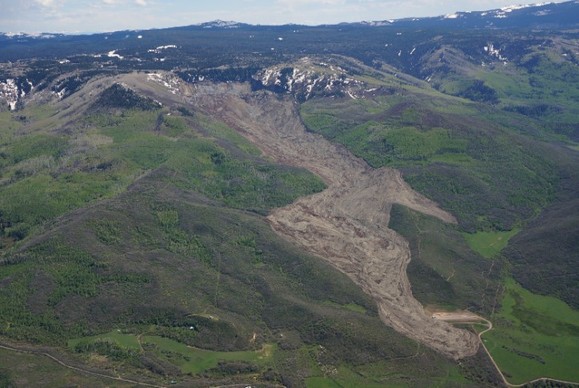
Landslide Assessment: West Salt Creek Landslide
Mesa County, Colorado Western Water Western Water & Land, Inc. (WWL) performed an evaluation of possible inundation areas in response to potential future failure and renewed movement of the debris resulting from the West Salt Creek Landslide. Potential inundation areas were delineated by using USGS Laharz™ software to model the planimetric area of the inundation hazard zones resulting from renewed movement of the landslide debris. Read more... |